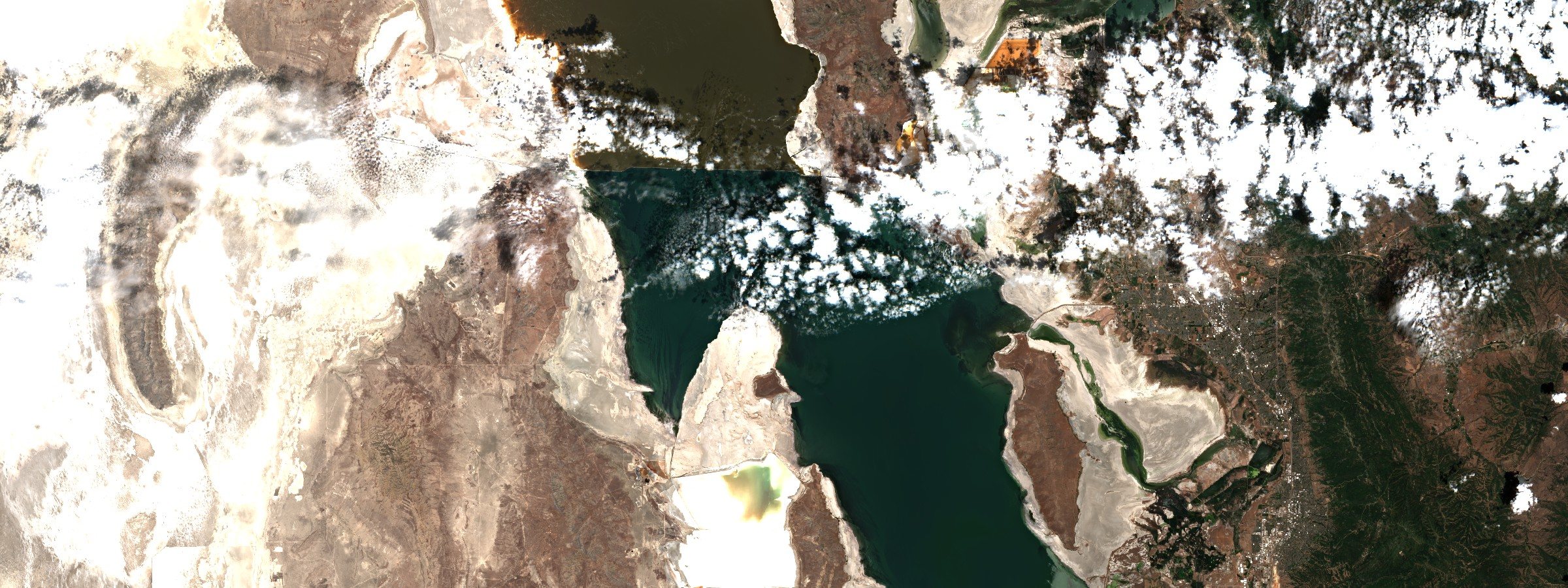
The lake that is mostly ashore
Great Salt Lake has gone from 2,300 square miles to under a thousand. What it uncovered is eight hundred square miles of lakebed sitting upwind of everybody, and the argument now is about who is allowed to measure it.
The surface
The last boats came out of the Great Salt Lake Marina on 3 August 2022. Weeks earlier the southern arm had touched 4,188.5 feet, the lowest reading anybody had ever taken there, and the slips were sitting on mud. In 1986 this lake covered about 2,300 square miles. In 2022 it covered under a thousand.
It has come back a little. A USGS gauge at Saltair reported the south arm between 4,189.5 and 4,189.9 feet in the middle of September, provisional and subject to revision, which is roughly a foot above the worst of it. A foot is not nothing. It is also not a lake, and the difference between those two statements is most of what Utah has been arguing about for four years.
Elevations and extent from the US Geological Survey; the September reading is provisional instantaneous gauge data from station 10010000.
What the wind takes
Some eight hundred square miles of lakebed now sit open to the wind. A soil survey run between 2016 and 2018 found roughly seventy of those square miles to be active dust hotspots, about nine percent of the exposed bed, concentrated at Farmington Bay and Gilbert Bay. The same survey put a ceiling on it: if the protective crusts keep degrading, or groundwater keeps dropping, hotspot area could reach 187 square miles.
A crust is the whole of the defense. Salt and clay and microbial growth knit the surface of a playa into something a forty-mile wind cannot lift, and where it holds the bed is quiet. Where it breaks, the bed is a source. That is the thing that does not match intuition about a dry lake: the danger is not the dryness, it is the moment the skin over it fails.
On 8 July 2026 a dust storm came off the bed and crossed the Salt Lake Valley. Kevin Perry, who has spent years on the playa on a bicycle taking samples, put the airborne particulate at roughly four times the level considered healthy. "I would say that the dust event that we had yesterday is dangerous," he told KSL. The acute response, he said, "can send people to the emergency room. It can lead to heart attacks. It can lead to stroke."
The danger is not the dryness. It is the moment the skin over it fails.
Exposed area and hotspot survey: Perry, Wilkes Center for Climate Science and Policy. The July figure is Perry's characterization as reported by the Salt Lake Tribune and KSL, not a monitor reading.
What is in it
Perry's survey found arsenic and lithium across the exposed playa above the EPA's residential screening levels for soil, arsenic highest against its own threshold. Then the useful sentence, which is about what is missing: there is no ambient standard for metals carried in dust. There is one for metals in soil. So a person breathing playa on a July afternoon is being compared against a number written for somebody's back garden, and there is not yet a threshold for the thing that is actually happening.
What the dust does biologically is a shorter file than people assume. Playa sediment from this lake carries higher oxidative potential than dust from Sevier Lake, Fish Springs, the West Desert or Tule Lake. A 2026 paper by Molly Blakowski and Janice Brahney at Utah State went further and looked at what happens when the dust lands on food: leafy vegetables took up arsenic and uranium, and thorough washing did not remove it. The authors are careful, and the care matters. They do not conclude the produce exceeds food safety standards. They conclude that it has not yet been measured.
"Dust is an acute health hazard, but rarely measured for composition or bioavailability of potentially toxic components," Brahney said when the paper came out. Kerry Kelly, a chemical engineer at the University of Utah, put the geography of it more plainly: "You're talking about a very large dust source located next to a very large population."
Metals and screening levels: Perry, 2026. Oxidative potential: Attah et al., Atmospheric Environment, 2024. Crop uptake: Blakowski, Brahney and Fernandez, Atmospheric Environment 373:121845, 2026.
Who is counted
Six PM10 monitors sit around Great Salt Lake. Owens Lake, which is about a fifteenth the size with a hundredth of the surrounding population, has nine. The Salton Sea has fourteen. Perry's report for the state says outright that the frequency and severity of these dust storms have not been quantified and that Utah does not yet have a network capable of supporting a mitigation determination.
The state is adding monitors. Its Utah Dust Observation and Research Network runs about twenty-three stations and will operate for at least five years, capturing dust events and heavy metals — and the agency's own description says they sit primarily in Wasatch Front communities. That is the right place to measure what people breathe. It is not where the dust is made, and those are different questions with different answers.
What the existing monitors have caught is modest. Between 2023 and 2025, three of seven stations near the lake recorded PM10 above the federal standard of 150 micrograms per cubic meter over twenty-four hours: Hawthorne once, Prison once, Tech twice. Four exceedances in three years. Bryce Bird, who directs Utah's air quality division, describes the picture as "one to ten instances a year where we have dust that we detect," and advises residents to "trust your senses." Perry's objection is not that the monitors lie. It is that "we don't have direct data for a lot of the communities that we think are most heavily impacted."
Four exceedances in three years is what the monitors caught, not what the playa produced.
Monitor counts and the quantification gap: Perry, 2026. Network description and exceedance record: Utah Division of Air Quality.
Whose lake
The bed that is blowing into Salt Lake City is also a burial ground. Rupert Steele, chairman of the Confederated Tribes of the Goshute Reservation, has said of the lake shore: "Our people are buried there. We have a spiritual connection to the area." Darren Parry, tribal historian and former chairman of the Northwestern Band of the Shoshone Nation, has put the governance question in one line: "How do you solve this problem without engaging with people who've managed the resource for thousands of years?"
He added the sentence that tends to get left out of the coverage. "Native Americans aren't relics of the past. We still have thriving cultures here."
Both quoted by KSL and the Salt Lake Tribune, 14 February 2023.
The levers
There are only a few things anybody can actually pull. One is a wall of rock. A berm in the Union Pacific causeway controls how water moves between the lake's two arms, and Utah raised it in the summer of 2022 and again the following winter on the governor's order. Brine shrimp cyst harvest went from about nineteen million pounds in 2022 to about twenty-nine million in 2023. Whether the berm caused that is not established; what is established is that a rock wall in a railway embankment is a lever, and that this lake's economy moves when somebody pulls it.
The second lever is stranger. In 2026 Utah's Division of Forestry, Fire and State Lands won a bankruptcy auction for the assets of U.S. Magnesium, an extraction works on the lake shore, after the legislature appropriated thirty million dollars so the state could take the company's water rights and give them to the lake. A state bought a failing magnesium plant to get at its water.
The third is engineering the bed itself, and it is priced. Perry costed twelve control measures over fifty years against those seventy square miles of hotspot. Tillage comes in at 3.2 billion dollars. Precision surface wetting comes in at 31.2 billion. Chemical suppressants, of which there are more than two hundred proprietary formulations in five broad categories, run to 12.7 billion, and most of them stop working inside a year.
Berm and harvest: KSL, February 2024. U.S. Magnesium: Fox 13 Utah, March 2026. Control costs and suppressant longevity: Perry, 2026.
The bed
A playa keeps an inventory. Arsenic and lithium in that soil are not this decade's doing; they are a century of mining and smelting and industry around a terminal lake with nowhere to send anything, settled into a floor that was under water and is not any more. The lake was the lid. Every foot of elevation it lost took some of the lid off.
Which makes the argument on the Wasatch Front an argument about sequence rather than about science. The state's own commissioned author says the hazard is not quantified. The state is building a network where the people are. The record shows four exceedances in three years, the modeling shows exposure rising as the lake falls, and the crusts holding down the other ninety-one percent of that bed have not yet been priced, because a crust costs nothing until it fails.
Exposure modeling: Grineski et al., One Earth 7(6):1056-1067.